 Mystery Los Angeles Neighborhood
About six weeks ago I realized that my old beige
G3 All-In-One (1998) was just taking up space on my computer desk.
The machine ran great and was my OS 9 lifeline for things like my scanner (not
natively supported under OS X), but the odd scanning job didn't seem to justify
the rather large amount of space taken up by that computer. Moreover, it had a
40GB hard drive in it, which I very much wanted in order to free up space on my
other external 40 GB drive. Basically, I needed to cannibalize the G3's hard
drive so my rather large MP3 collection could have its own drive and I could
once again store lots of unneeded applications and documents on the open space
of the old external. You following all this?
Bottom line: After saying a few words of appreciation for five years of unfailingly faithful service (I really did say some words!), I opened up the back of the G3 and ripped out its heart.
So, what to do with the empty hulk of a once proud computer? Recycle it, of course. The only problem, as I discovered, was where exactly to take it. I first loaded the machine into the car and took it over the great Santa Monica recycling station (quite literally Rhonelle's favorite place on the planet). After all when Rhonelle moved up north last year we just dropped off her very old Performa somethingorother and left. The nice man said we could. I figured the same would happen with the G3, but no dice. Instead, I had to drive onto the big scale thingy and was told it would be $.47/lb. to "dump" the computer (and some accessories) because I was not a resident of the People's Republic. Captain Math tells us that, at that rate, a 50 lb. computer would cost about $23 to recycle, and so I drove off the scale and drove back home miffed ("Those bastard commies won't take my machine? We left it the last time! Why, I'll just drive over there at 2 am and drop it off! That'll show them not to screw with well-intentioned people. Ha!") Of course, I knew that recycling electronics was no easy task because of the chemicals used in the circuit boards, among other things, but I thought enlightened government had figured out a way to eat that cost for the benefit of ecologically minded citizens. Oh well, time to look into what the CIty of Los Angeles had to offer.
[I really am getting to the mystery neighborhood, so please bear with me. Remember, it's my blog. :) ]
Later that day I discovered that Los Angeles does indeed offer a service for disposing of old electronics, but they're only open on the weekends. Fortunately there was a station in Playa Del Rey, just down the road; unfortunately I couldn't get there that weekend. In fact for various and sundry reasons, I couldn't get there until yesterday morning. But I got there at last and the computer has been properly disposed of.
Which brings me to the whole point of this entry: discovering (in the sense of Columbus "discovering" the Americas) a mystery right next to LAX.
You see, Yahoo! Maps told me to take surface streets from my apartment in Palms down to Playa Del Rey, which is right on the coast. I saw that the route went along Vista Del Mar St, which runs right up against the western edge of LAX -- it's the last road you see on the land as you whiz out to sea during take-off. I thought, cool, it will be interesting to see LAX from that vantage point and maybe a plane will fly over my head. More importantly, I wanted to see what the "bike paths" were all about. Bike paths? Yea, when you take off from LAX and look down there's this area just past the runway that, from the air, looks like a series of bike paths or walking trails. You know, for exercise and stuff.
Whoa, was I wrong. Here's what I'm talking about:
 (CLICK
FOR A LARGER IMAGE)
(CLICK
FOR A LARGER IMAGE)
(terraserver-usa.com)
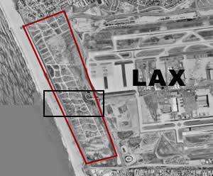
The red rectangle is the entire "bike path" area at the end of the runway. The black rectangle is coming up. Driving along Vista Del Mar St. gave me a great close-up of that area and revealed that those "bike paths" are actually roads. By that I mean they are streets! Here's a zoomed-in view of the black rectangle area above:
 (CLICK
FOR A LARGER IMAGE)
(CLICK
FOR A LARGER IMAGE)
(terraserver-usa.com)
Unfortunately I didn't have my camera with me, so I don't have any ground-level shots of these streets, but I could quite clearly tell that this whole area was once a neighborhood. The "landscaped avenue" in the above picture was clearly a nice tree-lined divided avenue back in the day. Moreover, you can still see where the houses sat -- the terraced hillsides for the lots were not cleared, just the houses themselves. It's all over-grown with weeds and things now, and the whole thing is fenced off with a tall fence topped by barbed wire (because it's part of the LAX site), so you can't just walk in and go exploring, but you can still see the streets. The land has shifted and broken up the concrete somewhat over the decades, but it's still apparent what was there.
Once I realized that the maze of paths was actually a maze of streets in a long-forgotten neighborhood I really wanted to know more about it. I guess the visibility of the streets themselves, in particular the nice divided avenue, made it all the more intriguing. After all, if the streets had been taken out along with the houses the whole thing wouldn't seem as interesting. But because the streets were left basically intact there's a much more distinct presence to the whole area. The old streets are a tantalizing reminder of what was once there, even if the LAX builders didn't necessarily intend to leave the streets as a "memorial." Who knows why they left the streets alone, probably for cost reasons and practicality concerns, but they did.
So, what was this mystery Los Angeles neighborhood all about before LAX took over the land, and what happened to the people who lived there? Were their houses demolished? Were the houses put on trucks and moved somewhere else?
So far, my Internet research has only turned up the following tidbit at the Los Angeles World Airports' (LAWA) history section:
1945
May 1 - $12,500,000 bond issue approved in a five-to-one landslide vote. This was for purchase of 1,860 acres to the west, expanding runways to 8,500 feet, and building temporary terminal facilities, now known as Cargo City. (my emphasis)
I wonder if this bond to purchase land to the west of the existing airport is the death knell for the mystery neighborhood? Also, the land itself seems to be (or was part of) the community of Playa del Rey, but their history section doesn't mention LAX. I've sent an email to the LAWA site asking to contact the "LAWA historian" indicated on their Community Relations page, so we'll see what happens. I'll certainly keep you, my faithful readers, informed...
Update 12/08/03
Just a couple of quick things as I work to figure out the story behind the mystery neighborhood next to LAX:
1. Drove back down there today and took a bunch of pictures.
Update 12/24/20 Old pictures gone. Google Maps view of the neighborhood site. (You can manipulate the view using the tools on that page.)2. When I saw that Sandpiper St. existed, I was hit with the idea that street maps of the area would show when the streets existed, what their names were, and when they stopped existing. So I went down to the Los Angeles Public Library and looked through a few Thomas Bros. guides. The earliest available at the library was from 1946 and, lo and behold, there was the neighborhood! I photocopied that page and will put it online soon. I didn't have time to find the exact year the neighborhood disappears from Thomas Bros maps, but I did see some aerial shots of LAX from the late 50s where the neighborhood seems to be gone. Also, there was a reference in the history of Playa Del Rey indicating that residents really started to flee the community as the airport expanded. No real timeframe given or any indication regarding the mystery neighborhood.
Update 12/09/03
Faithful reader Jasmin, using the newly implemented comments system here at PeteOfTheStreet Sayz, forwarded to me a web page reprinting a discussion of the threatened environment of the El Segundo Blue butterfly. The ESB, as the author Rudi Mattoni calls it, lives in the sand dune environment that at one time stretched from Palos Verdes in the south up to Santa Monica in the north. Increased urbanization in the twentieth century has severely affected the ESB and its habitat. Apparently, the mystery neighborhood was part of the LAX dune, the largest of the remaining dune areas.
While the page is primarily concerned with laying out the biological case for the dunes and the ESB (Mattoni is a professor of geography at UCLA), it also provides some incredibly significant historical data about the mystery neighborhood area. (Jasmin attempted to put some of this in her comments, but the comments are limited to 1000 characters) First:
"In l928 the grid of streets on the LAX dunes were constructed, but development was minimal following the l929 crash. It was not until after World War II that explosive development occurred, with virtually the entire dunes built upon between l946 and l965, where almost all the land was privately owned."
This tells us that the neighborhood was laid out in 1928, but that houses weren't much part of the area until after WW2. However, the most stunning part of the article comes later, when we get some details of why the neighborhood went away:
"A major cause of conflict arose from events attendant to the expansion of the Mines Field into the Los Angeles International Airport (LAX). The major radar installation (VOR) was located on a 60 acre site purchased in 1950. Home construction on the remainder of the dunes continued unchecked until into the 1960s. With increasing air traffic necessitating construction of the north runway, safety considerations and the onset of jet age noise, residential living conditions became increasingly difficult. In a 1965 referendum, over 66% of homeowners elected to be bought out with the remaining property condemned. Between l965 and l975, 822 homes were vacated and over 2000 people relocated. The $60 million cost was 75% reimbursed by the federal government."
So, the neighborhood lasted from 1946 to 1965 before the years of removal and vacancy began. Fascinating that it should show up in an article about butterflies. Also, this kind of ties in with the statement regarding Playa Del Rey residents "fleeing" the expansion of LAX, but it gives a lot more detail. I still wonder about the streets though? Why were they left? It must have been for practical reasons. I also have many other questions as well. The article references tables and figures, but unfortunately those weren't included in the online version (perhaps for copyright reasons?) so I'll have to hunt it down at UCLA tomorrow (Melvyl tells me it's "in process for SR" -- that doesn't look good). Mattoni worked with the Los Angeles Airport people, and I'm sure that's where he got some information, as well as pictures. I'd sure like to speak to them as well.
By the way, here's the map of the neighborhood as it looked in 1946. For a wider view, check out this map, also from 1946. Both of these are courtesy of the 1946 Thomas Guide. Interestingly, you can see that what I called "a landscaped avenue" was actually called Grand Pre Blvd. Neat, eh?
Update 12/10/03
Jasmin found the following reference to the mystery neighborhood (she mentioned it in a comment):
"1 Park at the top of Sandpiper St. (Playa del Rey) at the western departure end of LAX, and watch the fuel- and flesh-laden 747's lumber into the sky. Wonder if they'll make it? Sneak into the Blue Butterfly dunes, and observe the absurd suburb that was curbed before it could blurb." (original page)
Obviously this guy is to cool to bother with the real truth. The "absurd suburb" was not "curbed" in the way he's thinking. It was not removed to protect the ESB, as his statement implies. As we now know, the residents gave up their neighborhood in the onslaught of the LAX expansion. Silly little man. To hip to do research I guess...
UPDATE (11:45 pm): I went to UCLA this afternoon to look at Professor Mattoni's book on the ESB in order to see the photos he used. Unfortunately the book had been transfered to microfiche so the quality of the photos was really poor. Also, there was only one that might have showed the houses (from the 1950s). Alas, I suppose I really will have to visit LAWA to get a look at the real thing. I'm sure they've got lots of photos from the 1960s in preparation for the buyout. Or at least the city of Los Angeles might. I think I need to hire a research assistant. Any takers???
Bottom line: After saying a few words of appreciation for five years of unfailingly faithful service (I really did say some words!), I opened up the back of the G3 and ripped out its heart.
So, what to do with the empty hulk of a once proud computer? Recycle it, of course. The only problem, as I discovered, was where exactly to take it. I first loaded the machine into the car and took it over the great Santa Monica recycling station (quite literally Rhonelle's favorite place on the planet). After all when Rhonelle moved up north last year we just dropped off her very old Performa somethingorother and left. The nice man said we could. I figured the same would happen with the G3, but no dice. Instead, I had to drive onto the big scale thingy and was told it would be $.47/lb. to "dump" the computer (and some accessories) because I was not a resident of the People's Republic. Captain Math tells us that, at that rate, a 50 lb. computer would cost about $23 to recycle, and so I drove off the scale and drove back home miffed ("Those bastard commies won't take my machine? We left it the last time! Why, I'll just drive over there at 2 am and drop it off! That'll show them not to screw with well-intentioned people. Ha!") Of course, I knew that recycling electronics was no easy task because of the chemicals used in the circuit boards, among other things, but I thought enlightened government had figured out a way to eat that cost for the benefit of ecologically minded citizens. Oh well, time to look into what the CIty of Los Angeles had to offer.
[I really am getting to the mystery neighborhood, so please bear with me. Remember, it's my blog. :) ]
Later that day I discovered that Los Angeles does indeed offer a service for disposing of old electronics, but they're only open on the weekends. Fortunately there was a station in Playa Del Rey, just down the road; unfortunately I couldn't get there that weekend. In fact for various and sundry reasons, I couldn't get there until yesterday morning. But I got there at last and the computer has been properly disposed of.
Which brings me to the whole point of this entry: discovering (in the sense of Columbus "discovering" the Americas) a mystery right next to LAX.
You see, Yahoo! Maps told me to take surface streets from my apartment in Palms down to Playa Del Rey, which is right on the coast. I saw that the route went along Vista Del Mar St, which runs right up against the western edge of LAX -- it's the last road you see on the land as you whiz out to sea during take-off. I thought, cool, it will be interesting to see LAX from that vantage point and maybe a plane will fly over my head. More importantly, I wanted to see what the "bike paths" were all about. Bike paths? Yea, when you take off from LAX and look down there's this area just past the runway that, from the air, looks like a series of bike paths or walking trails. You know, for exercise and stuff.
Whoa, was I wrong. Here's what I'm talking about:
(CLICK
FOR A LARGER IMAGE)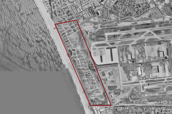
(terraserver-usa.com)
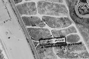
The red rectangle is the entire "bike path" area at the end of the runway. The black rectangle is coming up. Driving along Vista Del Mar St. gave me a great close-up of that area and revealed that those "bike paths" are actually roads. By that I mean they are streets! Here's a zoomed-in view of the black rectangle area above:
(CLICK
FOR A LARGER IMAGE)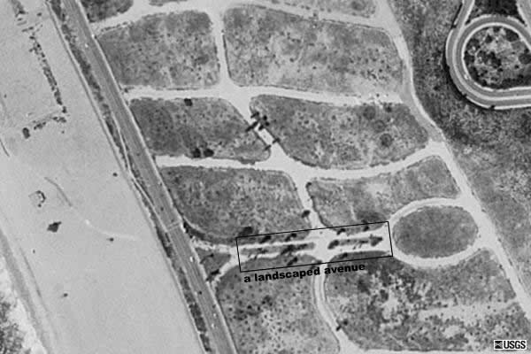
(terraserver-usa.com)
Unfortunately I didn't have my camera with me, so I don't have any ground-level shots of these streets, but I could quite clearly tell that this whole area was once a neighborhood. The "landscaped avenue" in the above picture was clearly a nice tree-lined divided avenue back in the day. Moreover, you can still see where the houses sat -- the terraced hillsides for the lots were not cleared, just the houses themselves. It's all over-grown with weeds and things now, and the whole thing is fenced off with a tall fence topped by barbed wire (because it's part of the LAX site), so you can't just walk in and go exploring, but you can still see the streets. The land has shifted and broken up the concrete somewhat over the decades, but it's still apparent what was there.
Once I realized that the maze of paths was actually a maze of streets in a long-forgotten neighborhood I really wanted to know more about it. I guess the visibility of the streets themselves, in particular the nice divided avenue, made it all the more intriguing. After all, if the streets had been taken out along with the houses the whole thing wouldn't seem as interesting. But because the streets were left basically intact there's a much more distinct presence to the whole area. The old streets are a tantalizing reminder of what was once there, even if the LAX builders didn't necessarily intend to leave the streets as a "memorial." Who knows why they left the streets alone, probably for cost reasons and practicality concerns, but they did.
So, what was this mystery Los Angeles neighborhood all about before LAX took over the land, and what happened to the people who lived there? Were their houses demolished? Were the houses put on trucks and moved somewhere else?
So far, my Internet research has only turned up the following tidbit at the Los Angeles World Airports' (LAWA) history section:
1945
May 1 - $12,500,000 bond issue approved in a five-to-one landslide vote. This was for purchase of 1,860 acres to the west, expanding runways to 8,500 feet, and building temporary terminal facilities, now known as Cargo City. (my emphasis)
I wonder if this bond to purchase land to the west of the existing airport is the death knell for the mystery neighborhood? Also, the land itself seems to be (or was part of) the community of Playa del Rey, but their history section doesn't mention LAX. I've sent an email to the LAWA site asking to contact the "LAWA historian" indicated on their Community Relations page, so we'll see what happens. I'll certainly keep you, my faithful readers, informed...
Update 12/08/03
Just a couple of quick things as I work to figure out the story behind the mystery neighborhood next to LAX:
1. Drove back down there today and took a bunch of pictures.
Update 12/24/20 Old pictures gone. Google Maps view of the neighborhood site. (You can manipulate the view using the tools on that page.)2. When I saw that Sandpiper St. existed, I was hit with the idea that street maps of the area would show when the streets existed, what their names were, and when they stopped existing. So I went down to the Los Angeles Public Library and looked through a few Thomas Bros. guides. The earliest available at the library was from 1946 and, lo and behold, there was the neighborhood! I photocopied that page and will put it online soon. I didn't have time to find the exact year the neighborhood disappears from Thomas Bros maps, but I did see some aerial shots of LAX from the late 50s where the neighborhood seems to be gone. Also, there was a reference in the history of Playa Del Rey indicating that residents really started to flee the community as the airport expanded. No real timeframe given or any indication regarding the mystery neighborhood.
Update 12/09/03
Faithful reader Jasmin, using the newly implemented comments system here at PeteOfTheStreet Sayz, forwarded to me a web page reprinting a discussion of the threatened environment of the El Segundo Blue butterfly. The ESB, as the author Rudi Mattoni calls it, lives in the sand dune environment that at one time stretched from Palos Verdes in the south up to Santa Monica in the north. Increased urbanization in the twentieth century has severely affected the ESB and its habitat. Apparently, the mystery neighborhood was part of the LAX dune, the largest of the remaining dune areas.
While the page is primarily concerned with laying out the biological case for the dunes and the ESB (Mattoni is a professor of geography at UCLA), it also provides some incredibly significant historical data about the mystery neighborhood area. (Jasmin attempted to put some of this in her comments, but the comments are limited to 1000 characters) First:
"In l928 the grid of streets on the LAX dunes were constructed, but development was minimal following the l929 crash. It was not until after World War II that explosive development occurred, with virtually the entire dunes built upon between l946 and l965, where almost all the land was privately owned."
This tells us that the neighborhood was laid out in 1928, but that houses weren't much part of the area until after WW2. However, the most stunning part of the article comes later, when we get some details of why the neighborhood went away:
"A major cause of conflict arose from events attendant to the expansion of the Mines Field into the Los Angeles International Airport (LAX). The major radar installation (VOR) was located on a 60 acre site purchased in 1950. Home construction on the remainder of the dunes continued unchecked until into the 1960s. With increasing air traffic necessitating construction of the north runway, safety considerations and the onset of jet age noise, residential living conditions became increasingly difficult. In a 1965 referendum, over 66% of homeowners elected to be bought out with the remaining property condemned. Between l965 and l975, 822 homes were vacated and over 2000 people relocated. The $60 million cost was 75% reimbursed by the federal government."
So, the neighborhood lasted from 1946 to 1965 before the years of removal and vacancy began. Fascinating that it should show up in an article about butterflies. Also, this kind of ties in with the statement regarding Playa Del Rey residents "fleeing" the expansion of LAX, but it gives a lot more detail. I still wonder about the streets though? Why were they left? It must have been for practical reasons. I also have many other questions as well. The article references tables and figures, but unfortunately those weren't included in the online version (perhaps for copyright reasons?) so I'll have to hunt it down at UCLA tomorrow (Melvyl tells me it's "in process for SR" -- that doesn't look good). Mattoni worked with the Los Angeles Airport people, and I'm sure that's where he got some information, as well as pictures. I'd sure like to speak to them as well.
By the way, here's the map of the neighborhood as it looked in 1946. For a wider view, check out this map, also from 1946. Both of these are courtesy of the 1946 Thomas Guide. Interestingly, you can see that what I called "a landscaped avenue" was actually called Grand Pre Blvd. Neat, eh?
Update 12/10/03
Jasmin found the following reference to the mystery neighborhood (she mentioned it in a comment):
"1 Park at the top of Sandpiper St. (Playa del Rey) at the western departure end of LAX, and watch the fuel- and flesh-laden 747's lumber into the sky. Wonder if they'll make it? Sneak into the Blue Butterfly dunes, and observe the absurd suburb that was curbed before it could blurb." (original page)
Obviously this guy is to cool to bother with the real truth. The "absurd suburb" was not "curbed" in the way he's thinking. It was not removed to protect the ESB, as his statement implies. As we now know, the residents gave up their neighborhood in the onslaught of the LAX expansion. Silly little man. To hip to do research I guess...
UPDATE (11:45 pm): I went to UCLA this afternoon to look at Professor Mattoni's book on the ESB in order to see the photos he used. Unfortunately the book had been transfered to microfiche so the quality of the photos was really poor. Also, there was only one that might have showed the houses (from the 1950s). Alas, I suppose I really will have to visit LAWA to get a look at the real thing. I'm sure they've got lots of photos from the 1960s in preparation for the buyout. Or at least the city of Los Angeles might. I think I need to hire a research assistant. Any takers???
Posted: Sunday - December 07, 3 at 03:09 PM
Quick Links
Statistics
Total entries in this blog:
Total entries in this category:
Published On: Aug 02, 2007 07:02 PM
Total entries in this category:
Published On: Aug 02, 2007 07:02 PM